Pakistan To Unveil Indigenous Remote Sensing Satellite
Pakistan To Unveil Indigenous Remote Sensing Satellite: Pakistan is set to launch PakTES-1A, an indigenously developed remote sensing satellite in July this year, said Foreign Office Spokesman Dr Muhmmad Faisal.
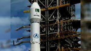
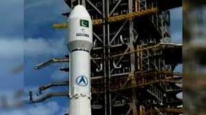
In a tweet, the spokesman said that PakTES-1A was an indigenously developed remote sensing satellite that weighed 285 kg.
It will be launched at 610 km sun-synchronous orbit in July 2018, he said and also shared the picture of the satellite’s model.
From concept till launch, Pakistan Technology Evaluation Satellite (PakTES-1A) is fully indigenous project of the scientists and engineers of Pakistan Space and Upper Atmosphere Research Commission (SUPARCO).
In a giant leap, Pakistan will launch its first indigenous satellite next month, putting Pakistan among the nations with advanced space technology.
The weight of satellite was 285 kilograms and it will be helpful for research in geography, climate and weather. The spokesperson said it will also be used for remote sensing.
Pakistan has also kick-started an ambitious space programme for the fiscal year 2018-19 to keep an eye on the Indian side and reduce its dependence on foreign satellites for civil and military purposes.
The satellite named PakTES-1A is an indigenously developed remote sensing satellite of Pakistan. It will be launched at 610-kilometre sun-synchronous orbit in July 2018. Until now, Pakistan has been relying on the US and French satellites for civil and military communications.
In 2016, Pakistan and China had signed an agreement for the launch of a special remote-sensing satellite in 2018. The agreement was aimed at monitoring the development of China-Pakistan Economic Corridor projects.
Many infrastructure projects are under construction throughout Pakistan under the CPEC. Originally valued at $ 46 billion, the value of CPEC projects is now more than $ 62 billion. The CPEC will link Pakistani Gwadar port to China’s Xinjiang province.
In 2012, Pakistan had completed its first remote-sensing satellite project. The Pakistan Space and Upper Atmosphere Research Commission, commonly known as SUPARCO, had set up its own version of Global Navigation Satellite System and immediately acquired the Beidou navigation system of China for this satellite in September 2012.
Presently, three satellites are under design by SUPARCO in collaboration with different universities throughout the country. The SUPARCO says that the first satellite of this programme had been scheduled to launch in July 2018, and it was expected to provide help in exploiting the potentials of space technologies for natural resource surveying and environmental purpose.
RSS technologies are used to detect and classify objects on earth, including on the surface and in the atmosphere and oceans, based on propagated signals.
In the budget presented in April for the fiscal year 2018-19, the government had allocated Rs4.7 billion ($40.7 million) to the SUPARCO. This was a 34 percent higher than the previous year’s budget allocation.
The budget includes Rs2.55 billion ($ 22 million) for three new programmes including $ 11.7 million for multi-mission satellite (PakSat-MM1) dedicated to live satellite television, broadband data transmission and emergency telecommunications services, $ 8.7 million for three “Pakistan space centre” sites in Karachi, Lahore and Islamabad and $ 1.7 million for the establishment of a “space application research centre” in Karachi.
Last year, the SUPARCO announced that the country was all set to launch two satellites, including its first remote sensing satellite, in early 2018. “Our first optical remote sensing satellite is all set to be launched in 2018” SUPARCO Chairman Qaiser Anees Khurram had said. The other, he said, will be an experimental satellite.
Khurram had said: “Remote-sensing satellite will have multiple benefits and practical applications, including agriculture, disaster management, urban planning, forestry, water management, weather forecast and other areas.”
The launching of the satellite will support Pakistan’s efforts for self-reliance amid tensions with the US. Only last month, the two countries had imposed tit-for-tat travel restrictions on each other’s diplomats suggesting a new low in their troubled ties.
For More Information & Videos Subscribe To Our YouTube Channel